![](/images/other/stat-length.png)
![Randonnée A pied Neuburg am Inn - Neuburg - Kohlbruck - Photo](https://media.geolcdn.com/t/1900/400/52cb660c-7041-4a1b-88d5-6f34785bd1a3.jpeg&format=pjpeg&maxdim=2)
Neuburg - Kohlbruck
SityTrail - itinéraires balisés pédestres
Tous les sentiers balisés d’Europe GUIDE+
![Longueur](/images/other/stat-length.png)
Longueur
8,3 km
![Altitude max](https://static1.geolcdn.com/siteimages/upload/files/1508320355ic_sort_altitude_max_24dp.png)
Altitude max
472 m
![Dénivelé positif](https://static1.geolcdn.com/siteimages/upload/files/1508320355ic_sort_den_pos_24dp.png)
Dénivelé positif
206 m
![Km-Effort](/images/other/stat-length.png)
Km-Effort
10,9 km
![Altitude min](https://static1.geolcdn.com/siteimages/upload/files/1508320355ic_sort_altitude_min_24dp.png)
Altitude min
411 m
![Dénivelé négatif](https://static1.geolcdn.com/siteimages/upload/files/1508320355ic_sort_den_neg_24dp.png)
Dénivelé négatif
167 m
![Boucle](https://static1.geolcdn.com/siteimages/upload/files/16400158638029165_repeat_loop_refresh_sync_direction_icon.png)
Boucle
Non
Balise
Date de création :
2022-02-11 15:07:07.5
Dernière modification :
2022-02-11 15:07:07.5
![A pied](https://static1.geolcdn.com/sitytour/trail-icons/100.png)
2h29
Difficulté : Facile
![Scannez ce code QR pour ouvrir la randonnée dans l'application SityTrail](https://capi.geolives.com/qq0zvz2zws4bq2lad0pu/sitytour/trails/3093854/qr.png?size=200)
Application GPS de randonnée GRATUITE
À propos
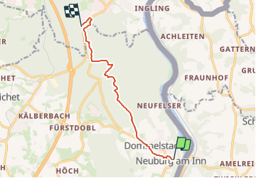
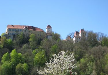
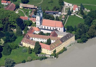
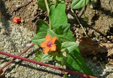
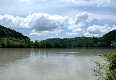
Randonnée A pied de 8,3 km à découvrir à Bavière, Landkreis Passau, Neuburg am Inn. Cette randonnée est proposée par SityTrail - itinéraires balisés pédestres.
Description
Randonnée créée par Bayerischer Wald-Verein e.V. Sektion Passau.
Localisation
Pays :
Allemagne
Région :
Bavière
Département/Province :
Landkreis Passau
Commune :
Neuburg am Inn
Localité :
Unknown
Départ:(Dec)
Départ:(UTM)
385489 ; 5373847 (33U) N.
Commentaires
Randonnées à proximité
![Randonnée A pied Rainbach im Innkreis - Schmankerlweg - Photo](https://media.geolcdn.com/t/375/260/d9324379-6ffe-4770-b657-5309f43fe3b0.jpeg&format=jpg&maxdim=2)
![A pied A pied](https://static1.geolcdn.com/sitytour/trail-icons/100.png)
Schmankerlweg
A pied
Facile
Rainbach im Innkreis,
Haute-Autriche,
Bezirk Schärding,
Autriche
![](/images/other/stat-length.png)
11 km | 14,1 km-effort
3h 12min
![](https://static1.geolcdn.com/siteimages/upload/files/16400158638029165_repeat_loop_refresh_sync_direction_icon.png)
Oui
![Randonnée A pied Wernstein am Inn - Rundwanderweg Stöbichen - Photo](https://media.geolcdn.com/t/375/260/0b321152-f4bc-4566-ad72-e0a06d114834.jpeg&format=jpg&maxdim=2)
![A pied A pied](https://static1.geolcdn.com/sitytour/trail-icons/100.png)
Rundwanderweg Stöbichen
A pied
Facile
Wernstein am Inn,
Haute-Autriche,
Bezirk Schärding,
Autriche
![](/images/other/stat-length.png)
6,8 km | 9,1 km-effort
2h 3min
![](https://static1.geolcdn.com/siteimages/upload/files/16400158638029165_repeat_loop_refresh_sync_direction_icon.png)
Oui
![Randonnée A pied Wernstein am Inn - Fronholzwarte - Photo](https://media.geolcdn.com/t/375/260/e67c2091-56ed-49ed-b002-5ff9c2820f07.jpeg&format=jpg&maxdim=2)
![A pied A pied](https://static1.geolcdn.com/sitytour/trail-icons/100.png)
Fronholzwarte
A pied
Facile
Wernstein am Inn,
Haute-Autriche,
Bezirk Schärding,
Autriche
![](/images/other/stat-length.png)
5,9 km | 9 km-effort
2h 2min
![](https://static1.geolcdn.com/siteimages/upload/files/16400158638029165_repeat_loop_refresh_sync_direction_icon.png)
Non
![Randonnée A pied Wernstein am Inn - Schärdinger Hütte - Fronholzwarte - Photo](https://media.geolcdn.com/t/375/260/4c623686-6c21-4b67-b62e-48c81c4153dd.jpeg&format=jpg&maxdim=2)
![A pied A pied](https://static1.geolcdn.com/sitytour/trail-icons/100.png)
Schärdinger Hütte - Fronholzwarte
A pied
Facile
Wernstein am Inn,
Haute-Autriche,
Bezirk Schärding,
Autriche
![](/images/other/stat-length.png)
13,6 km | 18,1 km-effort
4h 7min
![](https://static1.geolcdn.com/siteimages/upload/files/16400158638029165_repeat_loop_refresh_sync_direction_icon.png)
Oui
![Randonnée A pied Brunnenthal - Reickersbergweg - Photo](https://media.geolcdn.com/t/375/260/a4e9c7b7-958c-4da5-90e8-f68b3e1bb8db.jpeg&format=jpg&maxdim=2)
![A pied A pied](https://static1.geolcdn.com/sitytour/trail-icons/100.png)
Reickersbergweg
A pied
Facile
Brunnenthal,
Haute-Autriche,
Bezirk Schärding,
Autriche
![](/images/other/stat-length.png)
6,5 km | 8,9 km-effort
2h 1min
![](https://static1.geolcdn.com/siteimages/upload/files/16400158638029165_repeat_loop_refresh_sync_direction_icon.png)
Oui
![Randonnée A pied Brunnenthal - Innweg - Photo](https://media.geolcdn.com/t/375/260/af9eea9d-44a7-4093-830a-a3643d594dfc.jpeg&format=jpg&maxdim=2)
![A pied A pied](https://static1.geolcdn.com/sitytour/trail-icons/100.png)
Innweg
A pied
Facile
Brunnenthal,
Haute-Autriche,
Bezirk Schärding,
Autriche
![](/images/other/stat-length.png)
6,6 km | 8,7 km-effort
1h 58min
![](https://static1.geolcdn.com/siteimages/upload/files/16400158638029165_repeat_loop_refresh_sync_direction_icon.png)
Oui
![Randonnée A pied Schardenberg - Schardenberg - Passau - Photo](https://media.geolcdn.com/t/375/260/0fb0ff00-a260-4f64-ba98-81a90c03460c.jpeg&format=jpg&maxdim=2)
![A pied A pied](https://static1.geolcdn.com/sitytour/trail-icons/100.png)
Schardenberg - Passau
A pied
Facile
Schardenberg,
Haute-Autriche,
Bezirk Schärding,
Autriche
![](/images/other/stat-length.png)
6,9 km | 8,1 km-effort
1h 50min
![](https://static1.geolcdn.com/siteimages/upload/files/16400158638029165_repeat_loop_refresh_sync_direction_icon.png)
Non
![Randonnée A pied Neuburg am Inn - Inn - Kohlbruck - Photo](https://media.geolcdn.com/t/375/260/52cb660c-7041-4a1b-88d5-6f34785bd1a3.jpeg&format=jpg&maxdim=2)
![A pied A pied](https://static1.geolcdn.com/sitytour/trail-icons/100.png)
Inn - Kohlbruck
A pied
Facile
Neuburg am Inn,
Bavière,
Landkreis Passau,
Allemagne
![](/images/other/stat-length.png)
5,1 km | 7,1 km-effort
1h 37min
![](https://static1.geolcdn.com/siteimages/upload/files/16400158638029165_repeat_loop_refresh_sync_direction_icon.png)
Non
![Randonnée A pied Neuburg am Inn - Untere Innseite - Ingling - Photo](https://media.geolcdn.com/t/375/260/5c75e4fe-c27b-4da8-8e21-35839faf0d67.jpeg&format=jpg&maxdim=2)
![A pied A pied](https://static1.geolcdn.com/sitytour/trail-icons/100.png)
Untere Innseite - Ingling
A pied
Facile
Neuburg am Inn,
Bavière,
Landkreis Passau,
Allemagne
![](/images/other/stat-length.png)
6,2 km | 8,4 km-effort
1h 54min
![](https://static1.geolcdn.com/siteimages/upload/files/16400158638029165_repeat_loop_refresh_sync_direction_icon.png)
Oui